

Storm Update: Jan 1st EVENING
- WeatherSD

- Jan 1, 2023
- 2 min read
A strong storm system remains on track to impact South Dakota starting today and continue into Monday and parts of Tuesday. Winter Storm Warnings, Winter Weather Advisories, and even an Ice Storm Warnings are in effect for some counties in the state. For detailed information on the weather alerts for your area, check out Weather Alerts.
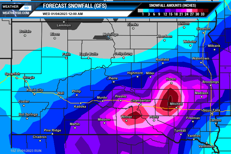
This evening, there remain some differences in the snowfall forecast with the three weather models. The heaviest snow looks to be somewhere in the southeast but the GFS (American) model is holding the heaviest amounts in western regions of the southeast and into south-central, South Dakota (mainly from Winner up towards Mitchell).
The ECMWF (Euro) model has been holding strong showing the heaviest amounts in the southeast mainly in the Yankton up towards Freeman and Canton and back into south-central, South Dakota.

The GEM (Canadiana) model is holding the highest amounts in south-central, South Dakota near the Platte, but the amounts are lighter than the other two forecast models.

Right now, those in the southeast and into east-central and south-central South Dakota stand the risk of significant snow amounts of six inches or greater. Please keep checking back for the latest information on the snowfall forecast as new data will be coming in. For the latest maps, you can also visit our Weather Maps page.
Below is a look at the timing of the storm system from the ECMWF (Euro) maps.


Besides the snow, the far southeast corner is under an Ice Storm Warning where those in Elk Point and toward Sioux City, Iowa could see ice accumulations from a quarter to half of an inch of ice along with one to six inches of snow.


