

Major Winter Storm During Work Week
- WeatherSD

- Dec 11, 2022
- 1 min read
A powerful winter storm looks to start impacting South Dakota on Monday and then get stalled over the area, bringing precipitation chances for Tuesday, Wednesday, and even on Thursday.
Currently, this is the thinking on this coming storm system. Starting Monday afternoon, precipitation, mainly rain, will push into the eastern and central regions of South Dakota. By the evening hours, some of that rain will mix with snow or produce freezing rain in the northeast and north-central. As the night moves on, precipitation will spread more in coverage, including western South Dakota. Snow is expected in the west with a mixture of rain, freezing rain, sleet, and snow for central regions and into a few locations in the north.
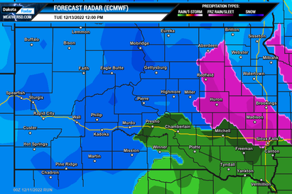
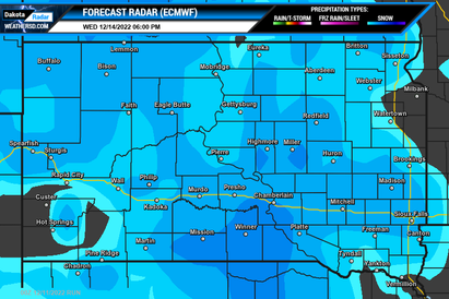
Tuesday morning, heavy snow is expected in the west, with blizzard conditions possible as wind gusts up to 50mph are possible. The central and northeast regions can see a mixed bag of snow, freezing rain, and rain with rain in the southeast. This will continue into the afternoon and evening hours on Tuesday before all the precipitation changes over to snow by late Tuesday night.
Below are two major weather forecast models, the American (GFS) and the Euro (ECMWF), from Sunday morning's runs showing the forecast radar starting Monday afternoon and going through early Thursday.
Forecast Radar Maps:


Major of the state is under weather alerts for this upcoming winter storm. Please visit our Weather Alerts page for the latest alert information for your location.
You can also check out your local forecast by stopping by our forecast website at forecastsd.com.


